Top Causes Of Errors In Online Mapping Systems
Two years ago, my brother was getting married, and he had asked me to help design his invitations and the maps showing how to get from the church to the restaurant where we were holding the rehearsal dinner. I used to be a professional cartographer, so making a map was not a problem, particularly since […]
Two years ago, my brother was getting married, and he had asked me to help design his invitations and the maps showing how to get from the church to the restaurant where we were holding the rehearsal dinner. I used to be a professional cartographer, so making a map was not a problem, particularly since online mapping has made it easy enough that any internet user could do it. I was going to find a nice map image and then paste it up with page layout software to print up directions.
Despite being very careful, I ended up making an incorrect map, sending a caravan of cars containing tired, grumpy wedding participants off to the wrong place, and my brother was ready to kill me.
My experience in getting an erroneous map from the web isn’t all that uncommon,
and most avid internet users have been tripped up at some point by errors found
in online mapping systems.
So, why do these mapping errors happen so frequently?
Back when I worked at Superpages.com, I frequently skimmed all the email notes that were sent through our feedback form, and the number one most frequent complaint them was mapping errors. Since Superpages contracted with online mapping providers for the maps, we were limited in what could be done to correct them in a lot of cases. Map errors were not something unique to Superpages, but something that is a big problem with all online mapping providers.
Causes of internet map errors range from digital mapping methodology, data errors, data interpretation errors, usability errors, and errors in interpreting user queries.
There are quite a number of sources of errors in online maps, and I’ll outline
a few here.
- Much of the map data that was used at the beginning of the creation of software mapping systems in the U.S. was based off of government data used by the Census Bureau, in a format called TIGER files ("Topologically Integrated Geographic Encoding and Referencing").
The TIGER/Line Shapefiles contain points, polylines, and polygons, which describe locational features such as roads, rivers, lakes, county outlines, etc. I believe that online mapping systems likely are still using data derived from these files today.
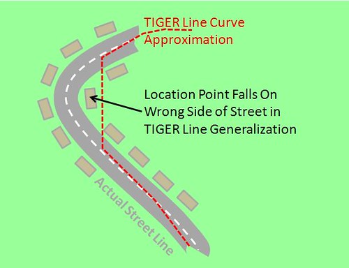
Unfortunately, the vector shape files break curved lines down into straight line segments, and there are cases where the straight line approximation of curved features can make locations get pinpointed erroneously. For example, a curved street that is broken down too bluntly could make a mapped location point appear to be on the wrong side of the street in digital maps:

(This illustration is pretty exaggerated, and the definition of curved shapes has improved in TIGER files in recent years, but this still shows the sorts of errors that could occur from having curved lines broken down into straight-line segments.
Shapefile definitions currently do not include Bézier curves which could more accurately represent the real world.)
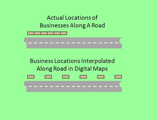
- Census data can tell what blocks of address numbers are associated with segments of streets and roads, but doesn’t provide precise geocodes for each address. Due to this, online mapping systems often interpolate (distribute evenly) addresses along each side of a street when, in fact, business addresses may all be clumped up at one end of the street.
- Online mapping providers obtain additional mapping information from many other sources, particularly from state and local government offices. All this data takes a while to be absorbed and integrated with already-existing mapping data, so there’s typically a lagtime between when new street information is obtained and made available for online users. This issue is particularly frustrating for business owners who have just opened up in a new area, since their streets may not be seen in the online maps for quite some time. New streets and new addresses sometimes cannot be mapped properly for up to a year after a new street opens up.
- People use quite a lot of software packages out there to generate geographic coordinates for street addresses. These longitude and latitude values are used in a coordinate pair like an X/Y coordinate set to pinpoint locations across the word’s grid. (For instance, see the mapped pinpoint of the Gateway Arch in St. Louis.) All these geocoding software packages use some really great math to estimate where a street address’s coordinates should fall, but this estimation is still a far cry from going in person and measuring where an address’s geocoordinates actually fall, and there’s an inevitable error rate associated with the geocoding exercises used by the online mapping providers and other local search information companies.
- In many large cities, streets may have both a North/South or East/West address numbering system, and this sometimes confuses online map systems as they try to tell which address a user may be requesting, and whether an business should be displayed at one end of a street versus another. (This is the issue which caused my brother’s wedding map to be messed up. I sent guests driving to the wrong end of the street.)
- Local search providers obtain business information from a great many sources, and all of those sources may abbreviate common notations in different ways: Elm Street, Elm St., Elm — or Smith Road, Smith Rd., Smith Rd., Smith Highway, Smith Hwy., Smith Freeway, Smith Fwy, etc.
Local search companies have to associate all these varying notations with the addresses they have in their databases, and in situations where they fail to do so, they sometimes
show duplicate listings. - User queries are often difficult to interpret and associate with the correct addresses, for similar reasons. Users may write address names and abbreviations in numerous different ways, and in areas where just a slight difference in typing out a name can mean the difference in mapping to a correct address versus another similar address, this can result in a lot of errors. For example, see "Washington
Rd, Houston, Tx" - When online mapping systems do not know the correct location for an address, they often will still generate a map for the user, making a map pinpoint default to the center of a ZIP code area, or default to the centroid of a city. There are instances when such systems do not clearly alert the end user that they have done this, and that can result in users driving around, lost. This lack of clear warning to the user that the map is extremely generalized is very bad.
This issue can happen most frequently with partners of online map providers who may not have properly coded in all map error handling messages available in the map providers’ APIs.
- One of the hardest things to clean up in online business directories is stale business listings — businesses which may have moved or gone out of business. When the online mapping directories and local search providers pull in this stale data, it can result in users driving to former business addresses, only to find nothing there.
- The slight differences between various mapping systems can also result in pinpointing errors. When an address is geocoded for one particular mapping system, and then that set of geographic coordinates is carried over for display in another mapping system, slight variances between the two can result in significant errors. This particular issue is likely very rare, and probably only affects areas of particularly dense numbers of locations, such as in larger cities.
Although there are still considerable degrees of error in online maps just as there were ten years ago, progress is slowly being made. Most map data providers have been improving their game for accuracy, and each of the local search and mapping providers have also tried to correct as much as they’re able. Most of the internet yellow pages and local search sites allow business owners to correct their addresses in some way, and Google recently opened up to allow all their Maps users to edit and correct mapped locations.
I’d really like to see every online mapping provider post an information page explaining their methods for reducing map error, and their policies for how frequently they update map data from their various sources. Currently it is very difficult to tell which mapping providers have the lowest error rates, and since many internet users like myself have experienced bad map pain from time to time, it would be reassuring to see that online map companies are taking this seriously and aggressively working on error reduction.
Also, if you’re interested in optimizing your small business website to facilitate potential customers to be able to find you, here's some tips for including maps on websites.
Opinions expressed in this article are those of the guest author and not necessarily Search Engine Land. Staff authors are listed here.
Related stories
About the author