Friday Maps Mania: Street View Back In Europe, “Wi-Spy” Accusations In US, Mapquest Opens Up & Put Your Check-ins On The Map
With lots of mapping news today, we’re combining it all into a single round up, which focuses largely on Google. The company decided, after suspending, examining and “scrubbing” its Street View equipment in Europe and elsewhere, to resume collecting imagery and related data in several countries: Having spoken to the relevant regulators, we have decided […]
With lots of mapping news today, we’re combining it all into a single round up, which focuses largely on Google. The company decided, after suspending, examining and “scrubbing” its Street View equipment in Europe and elsewhere, to resume collecting imagery and related data in several countries:
Having spoken to the relevant regulators, we have decided to start Street View driving in Ireland, Norway, South Africa and Sweden again starting next week. We expect to add more countries in time. Our cars will no longer collect any WiFi information at all, but will continue to collect photos and 3D imagery as they did before . . .
Despite this effort, it’s not clear that European privacy authorities are ready to let Google completely off the hook. But the company should get points for quickly admitting the mistake and promptly addressing the issue.
Back in America, however, one entity that’s not ready to let Mountain View off the hook is Consumer Watchdog. The advocacy group is back with “Wi-Spy” allegations. Those assertions argue that Google has potentially — emphasis on the word potentially — captured sensitive information from several members of Congress whose homes were on Street View routes:
Google’s WiSpy snooping could have sucked up and recorded communications from members of Congress, some of whom are involved in national security issues, an investigation by Consumer Watchdog’s InsideGoogle.com has found.
Rep. Jane Harman, D-CA, a current member of the Homeland Security Committee and former member of the Intelligence Committee has at least one wireless network in her Washington, D.C., home that could have been breached by Google, Consumer Watchdog said.
The consumer group has written Harman and 18 other members of the House Energy and Commerce Committee whose homes are pictured on Google’s Street View which suggest their WiFi networks were scanned, and called for immediate hearings.
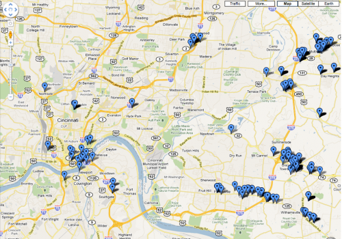
As others have pointed out, it’s unlikely that there were state secrets or national security information in Congressional Members’ private home email accounts or stored on their personal computers (let’s hope not). According to the persistent Google critic, below are the Representatives’ homes Google captured on Street View (see the full list here.)
While it’s important to protect privacy and “keep Google honest,” it appears there’s a bit of opportunism here on the part of Consumer Watchdog to inflame fears about Google and Street View. And now on to the less controversial “mapping features” part of the discussion.
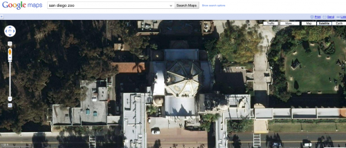
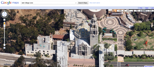
Google has introduced what it’s calling 45° imagery. This is aerial imagery showing more than simply the rooftops of buildings and associated HVAC equipment. Below are a couple of representative shots; compare the unsatisfying satellite image with the more useful 45° photography:
I’ll get the call from Microsoft PR if I don’t point out that Bing Maps (rather its predecessor) has offered this type of view (“Bird’s Eye”) since late 2005.
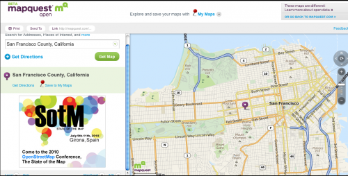
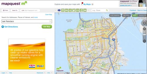
The even more venerable Mapquest this morning introduced a new UK-based site built on OpenStreetMap, which will “live side-by-side” with Mapquest’s other UK site. Called Mapquest Open, it uses the crowdsourced maps and data of the open-source mapping project. AOL also contributed a million dollars to support the effort.
Here are two images that compare traditional (though recently redesigned Mapquest) with Mapquest Open (Open is first):
Mapquest Open is the direction that the company wants to go longer term. According to the release out earlier today:
“We believe that open source is ultimately the future for AOL’s local and mapping applications. And we’re very excited about supporting OpenStreetMap, which powers the maps behind Patch, our local news and information platform. We believe community generated maps that are of high quality and accuracy will end up ultimately being the better mapping product for users.
The final item today, to come full circle in a sense, offers a way to visualize your Foursquare check-in history on a Google Map:
Contributing authors are invited to create content for Search Engine Land and are chosen for their expertise and contribution to the search community. Our contributors work under the oversight of the editorial staff and contributions are checked for quality and relevance to our readers. The opinions they express are their own.
Related stories
New on Search Engine Land
