Google Maps Causes US Navy To Change Its Swastika Building
You have to feel a bit sorry for the US Navy. They have a building in California that looks like a swastika from the air. But who looks at buildings from the air? Until Google Maps popularized easy access to aerial views, only the occasional bored air traveler. But thanks to Google Maps, the swastika […]

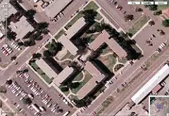
You have to feel a bit sorry for the US Navy. They have a building in California that looks like a swastika from the air. But who looks at buildings from the air? Until Google Maps popularized easy access to aerial views, only the occasional bored air traveler. But thanks to Google Maps, the swastika building got known, discussed, and now is being camouflaged.
Google Maps forces Navy to redesign swastika building from Chris Silver Smith covers how he contributed to what happened by posting a picture he spotted of the building. Now it’s made a CNN report, because as he explains, the US Navy will spend $600,000 in landscaping and new structures to break up the pattern in order to eliminate complaints over it.
Here’s the building on Google Maps itself:
I was curious about how it would look at street level, but Google doesn’t have its Street View photography in this part of the San Diego area.
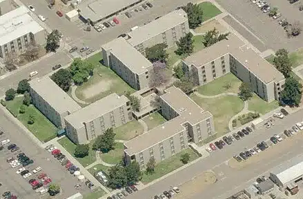
Over at Windows Live Local, there’s a "Bird’s Eye View" of the building:
The swastika shape is still pretty visible there. Windows Live also offers 3D views. Interesting enough (especially for conspiracy theorists), that building is rendered in 3D while several nearby buildings are not. Microsoft says 3D views are done mostly on an automated basis, so I really wouldn’t read much into this. That building, along with a nearby dome structure, are unusual shapes that the software might be triggered to pick out.
One plus to having the 3D view is that I can use that to show you a simulated street level view:
From the street, the swastika, of course, disappears.
Postscript: Navy to mask Coronado’s swastika-shaped barracks covers how the designed was noticed after groundbreaking in 1967 but a decision was made not to change things, since it wasn’t visible from the ground. Meanwhile, Navy Bombers attacking Swastika Building from Microsoft’s Virtual Earth Blog touches on what I mentioned above, how this was somehow automatically selected to be rendered in 3D when two nearby buildings were not. It also hightlight a comment from someone suggesting the other two buildings are bomber-shaped, heading to bomb the swastika symbol. If these were WWII-era buildings, just maybe that might make sense. Not for 60s-era buildings.
Contributing authors are invited to create content for Search Engine Land and are chosen for their expertise and contribution to the search community. Our contributors work under the oversight of the editorial staff and contributions are checked for quality and relevance to our readers. The opinions they express are their own.
Related stories
New on Search Engine Land

