Google Earth Adds World War II Imagery
The Google LatLong Blog announced the addition of World War II imagery to Google Earth. Now you can compare, side by side, the earth as it is today versus how it was during World War II. Google said: Images taken in 1943 show the effect of wartime bombing on more than 35 European towns and […]
The Google LatLong Blog announced the addition of World War II imagery to Google Earth. Now you can compare, side by side, the earth as it is today versus how it was during World War II.
Google said:
Images taken in 1943 show the effect of wartime bombing on more than 35 European towns and cities. Imagery for Warsaw, which was heavily destroyed at the time, is available from both years 1935 and 1945. They remind us all of the devastating impact of war on the people in those cities and also the remarkable way in which urban environments are reconstructed and regenerated over time.
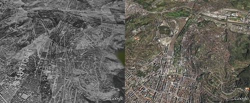
Here is a picture, side by side, of German city of Stuttgart:
Search Engine Land is owned by Semrush. We remain committed to providing high-quality coverage of marketing topics. Unless otherwise noted, this page’s content was written by either an employee or a paid contractor of Semrush Inc.