Visualize Earthquake Data In Google Earth
The US Geological Survey and Google are now making global earthquake data available in Google Earth as one of the layers under “Places of Interest.” According to the USGS: USGS and Google signed an agreement to publish historic earthquake data from the Advanced National Seismic System (ANSS) catalog as a “built-in” layer, accessible directly from […]
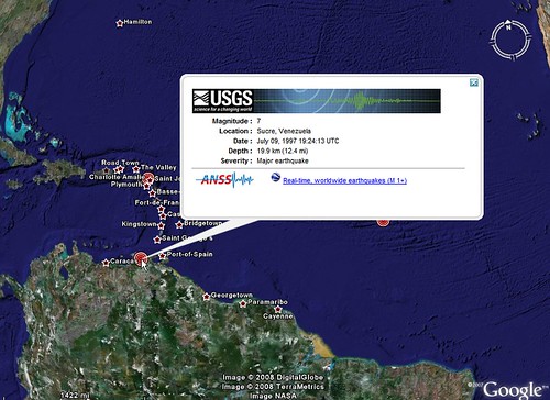
The US Geological Survey and Google are now making global earthquake data available in Google Earth as one of the layers under “Places of Interest.”
According to the USGS:
USGS and Google signed an agreement to publish historic earthquake data from the Advanced National Seismic System (ANSS) catalog as a “built-in” layer, accessible directly from the Google Earth viewer . . . The new layer includes historic earthquakes since 1900, and USGS real-time earthquakes are now accessible as a hyperlink from within Google Earth. If the layer is checked, users will see a sprinkling of dots across the globe, each marking an earthquake epicenter.
To display the earthquake locations in the Google Earth viewer, go to the layers menu, and look in the folder “Places of Interest.” Open the “Geographic Features” folder, and click on “Earthquakes.”
Contributing authors are invited to create content for Search Engine Land and are chosen for their expertise and contribution to the search community. Our contributors work under the oversight of the editorial staff and contributions are checked for quality and relevance to our readers. The opinions they express are their own.
Related stories
New on Search Engine Land
About the author