New Google Maps “Digital Timeline” Shows Street View Images Dating Back 7 Years
Google Maps has launched a cool new feature for its Street View images that lets you see past pictures of various landmarks dating back seven years. From the announcement, “If you see a clock icon in the upper left-hand portion of a Street View image, click on it and move the slider through time and […]
Google Maps has launched a cool new feature for its Street View images that lets you see past pictures of various landmarks dating back seven years.
From the announcement, “If you see a clock icon in the upper left-hand portion of a Street View image, click on it and move the slider through time and select a thumbnail to see that same place in previous years or seasons.”
Going back to 2007, the “digital timeline” offers images of various locations, including New York City’s Freedom Tower:

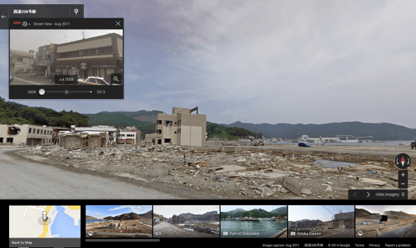
The announcement also included images of Onagawa, Japan, showing how the feature could be used to see the areas impacted by the tragic 2011 earthquake.
Google recommended travelers could use the feature to see what a destination looks like during different seasons.
Contributing authors are invited to create content for Search Engine Land and are chosen for their expertise and contribution to the search community. Our contributors work under the oversight of the editorial staff and contributions are checked for quality and relevance to our readers. The opinions they express are their own.
Related stories
New on Search Engine Land
About the author