Where’s Waldo? According To Google Maps, Colorado Wildfire Burning Near Chicago
I live in Colorado, where we’re experiencing an unprecedented number of wildfires this summer—reportedly, fully 50% of country’s firefighting resources are currently stationed here. I’m not in any personal danger (at the moment) but like most people living here I’m closely tracking news of the fires and am very concerned for those who are at […]
I live in Colorado, where we’re experiencing an unprecedented number of wildfires this summer—reportedly, fully 50% of country’s firefighting resources are currently stationed here. I’m not in any personal danger (at the moment) but like most people living here I’m closely tracking news of the fires and am very concerned for those who are at risk from the rapidly spreading flames.
All wildfires are given names, usually based on where they started. One of the scariest burning right now is called the “Waldo Canyon” fire, just west of Colorado Springs. While Twitter is proving an invaluable source of local news, the Denver Post is also updating news of the fire frequently, and fire officials have stated that their goal is to “keep the fire north of U.S. 24.”
To help track the fire, the Post is using Google maps to display an interactive perimeter map of the fire area, so it’s easy to see the fire’s location in relation to U.S. 24. While the map is accurate geographically (at least based on my personal experience in the area), it also clearly labels U.S. Route 24 near the fire as being in Illinois:
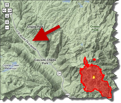
Just goes to show you can’t always believe everything you read on the internet…
Contributing authors are invited to create content for Search Engine Land and are chosen for their expertise and contribution to the search community. Our contributors work under the oversight of the editorial staff and contributions are checked for quality and relevance to our readers. The opinions they express are their own.
Related stories
New on Search Engine Land
About the author