Bing Maps Shows Super Bowl Spirit With New Venue Map, Streetside & Hi-Res Venue Imagery
Recent image updates show University of Phoenix Stadium being prepped for Sunday's Super Bowl.

Recent image updates show University of Phoenix Stadium being prepped for Sunday's Super Bowl.
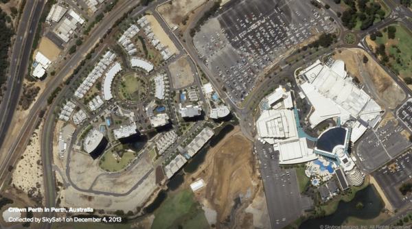
There’s a report this morning that Google is close to buying satellite imaging company SkyBox. The purchase price is put at roughly $1 billion. The deal has yet to be confirmed. The article conjectures that Google wants the company for two potential reasons: More imagery for consumer maps Data for enterprise use cases I’m sure those are accurate assumptions. […]

Google Maps is making an exception to its process for reviewing image removal requests, and speeding up the actions needed to replace a satellite image of a 14-year old shooting victim. Following a story broadcast on KTVU-TV, a CNN affiliate in Oakland, California and a report on CNN.com, Google claims it will take approximately eight days […]
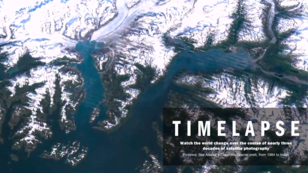
The new Timelapse site, created by Time Inc. and Google, is a pretty amazing way to see how any part of the world has changed since 1984 through 2012. The site offers amazing animations such as the growth of Las Vegas and the shrinking of the Columbia Glacier, and you can point it at any […]
Bing Maps has announced a series of updates to its high-resolution imagery, including expanded coverage, better mapping of ocean floors, cloud filtering and more. The prime features that Bing is touting involve what it calls “top of the world” imagery — those hi-res, top-down images. Improvements there include: Cloud cover filtering: Bing processes its base […]
As the “mapping wars” heat up Microsoft is introducing a huge new body of satellite imagery into Bing Maps. It’s not clear whether any of this will extend to mobile given the apparent substitution of Nokia Maps for Bing in Windows Phone 8. The new imagery covers vast amounts of land on almost every continent. […]
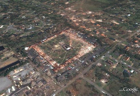
Google has posted before-and-after images of the terrible devastation left behind by the tornadoes that hit the South and parts of the East Coast of the United States earlier this week, with close-up views particularly of Tuscaloosa, Alabama. The easiest way to see the images is through a Picasa album that the company has posted. […]
From company logos to swastikas, marriage proposals and other messages, you can find some very unique images in Google Maps. And now, according to some construction workers in England, you can also find a vision of the Virgin Mary holding baby Jesus. That’s a close-up of what Google Maps shows at a construction site along […]
Google has captured a bunch of new satellite imagery that shows the devastation of the 8.9 earthquake and tsunami in Japan. You can see those images in Picasa or on Google Earth with a KML file (Japan Earthquake and Tsunami). Separately Google has set up a “people finder” for those still missing in Japan. It […]
When I heard yesterday that a volcano in Iceland had erupted and that airports across Europe were closed I thought it was a joke. But unfortunately it wasn’t. The volcano, Eyjafjallajökull (no that’s not misspelled), sent ash out into the sky for miles. The ash apparently creates a dangerous condition for planes, and so most […]
Bing Maps has rolled out what Microsoft is calling its “largest amount of new imagery ever in terms of square kilometers.” Apparently that represents 6.7 million square kilometers. There’s new aerial and Bird’s Eye imagery across many countries on several continents. The full list is below. The Bing Maps World Tour shows the updates on […]
Both Google Maps and Bing Maps offer ways to see the devastation caused by the earthquake in Haiti. Below, a look at how to see before and after images, taken by satellite. Plus, several 360-degree ground level videos you can view. 360-Degree On-The-Ground Video Immersive Media has released a number of 360-degree view videos of […]
Virtual Earth, which has been somewhat in the shadow of Google Maps and Earth released a large volume of new images for Live Search Maps for a range of countries and cities around the globe. The imagery allows you to get in very close, so you can see how far your hotel is exactly from […]
A California lawmaker has introduced a bill that would limit what Google Maps and other online mapping sites are allowed to show, on the basis that these online tools help terrorists plan attacks. We’ve been here before: Late last year, the Indian government suggested that Google Earth should be censored after terrorists involved in the […]
Citing the Mumbai terrorists’ statement that they used Google Maps as a planning tool, a California legislator (from El Cajon) has introduced a bill which would “not allow online mapping tools from companies like Google Inc. to provide aerial or satellite images of schools, places of worship, government buildings and medical facilities unless they have […]
The Virtual Earth Blog announced their first 2009 imagery update, including about 100TB of new images. The major updates include the new Digital Globe satellite imagery they recently licensed and “bird’s eye” photos of Paris, France. There are literally tons of updates to the imagery, from satellite to bird’s eye to orthos. For the full […]
Google is having a special event today featuring former US vice president Al Gore to announce its new Google Earth 5.0 software that features new underwater views of the world’s oceans (Google Ocean) and 3D views, as well as “historic imagery” that allows people to see the earth back in time through archived satellite views […]
The Virtual Earth Blog announced that they have updated the data and images for some locations. The update includes data refreshes to Greece, Estonia, Latvia, Lithuania, Kaliningrad Oblast of Russia, Slovakia, Hungary, Slovenia, Croatia, Bosnia and Herzegovina, Serbia, Montenegro, Former Yugoslav Republic Of Macedonia, Albania, Bulgaria, Romania and Mexico. In addition Microsoft did global vector […]
On the heels of the tragic terrorist attacks in Mumbai last month, legal advocates in India are asking the country’s High Court to demand that Google blur sensitive locations on Google Earth. The Times reports that the Indian petition says Google Earth “aids terrorists in plotting attacks” and offers “absolutely no control to prevent misuse […]
New satellite images that will eventually show up in Google Earth and Google Maps are now arriving from the Google-sponsored GeoEye-1 satellite that launched a month ago. GeoEye has just released the stunning image below as a preview of what’s to come:
Google has moved off land, into the sea and the sky (space) to further some of its earthly objectives. On Saturday the GeoEye-1 satellite launched into space. The noteworthy thing about this satellite is that it has the highest resolution of any orbiter taking pictures of Earth.
The Virtual Earth Blog announced that they have released a bulk of new imagery to Virtual Earth and Live Maps. I am not going to list out all the new locations where you can find the new satellite, ortho, and bird’s eye imagery, but here are a few:
Yahoo has largely opted out of the mapping arms race between Microsoft and Google that has seen both invest millions in their mapping platforms. While it was the early pioneer of dynamic mapping and use of maps as a local search tool, the company decided to focus on more “practical” tools and functionality rather than […]
Google Earth is constantly obtaining new satellite images and updating their old ones. The Google Earth Blog stays on top of most these updates and has notified us of a recent update where Google has added more detailed imagery of Spain. The Google Earth Blog reports the imagery update covers the eastern edge of Spain, […]
The introduction of satellite images into map search interfaces has excited both virtual sightseers and local app developers. Further innovations like Google’s Street View have caused consternation from privacy advocates while further pumping up the buzz about online mapping. In 2008, we can expect further innovations that stretch the envelope while dynamic map interfaces solidify […]
The Google Earth Blog has a humorous discussion of the “world’s largest KFC logo” in the Nevada desert. KFC stands for Kentucky Fried Chicken, the US-based fast-food chain. This stunt is about being visible in satellite mapping applications (such as Google Earth) and takes the rooftop logo craze to new heights and lengths — literally. […]
Gary Price points to a Microsoft Virtual Earth blog posting that reflects enhancements of low level orthogonal “Bird’s Eye” photography within the U.S., as well as satellite mapping for a range of countries and locations outside the U.S. In addition there’s also now more 3-D imagery and more 3-D cities in Virtual Earth.
Google goes back to pre-Katrina maps from USA Today reports that Google Maps has changed their satellite imagery of New Orleans to show pre-Katrina images, getting some local residents angry and wondering if there’s some type of cover-up in the works. However, it’s unclear if these are pre-Katrina images or not — and the situation’s […]
Philipp Lenssen a couple days ago reported Super-Close Google Maps Zooms which got many people saying wow! Philipp discovered that these high-resolution images of camels, people, swimming pools and beach goers was actually from featured content in Google Earth, visible through Google Maps via hacked URLs. Google Sightseeing has a nice explanation of how these […]
Still somewhat ahead of consumer demand, Microsoft continues to build on its commitment to rich satellite and aerial imagery (in addition to 3-D) through its Virtual Earth platform (and Live Local destination). Earlier today Microsoft announced that it will integrate more than 400,000 square miles of U.S. aerial imagery into Virtual Earth, under an agreement […]